Plus Codes instead of Latitude/Longitude in Google Maps
Where did the latitude and longitude go? Why?
If you search for (or click on) a location in Google Maps, the map coordinates of that location are provided as a Plus Code, instead of a latitude and longitude. Why?
Many of us take our street addresses for granted. In many areas of the world, including developed countries, there are locations that people, mail, and services need to reach without the benefit of named streets and roads. These locales range from remote areas to densely populated cities where street addresses are not assigned, whether the roads are named or not. In these areas, homes and businesses can be found only via directions relative to often impermanent landmarks.
These direction-based "addresses" are often literally, "the blue building, 100 meters east of the city bus terminal" or "the hotel located 150 meters north of Joe's Restaurant". You'll see a real-world example in a second.
In mapping, latitude and longitude have long been used to define locations that don't have addresses, but is there really anything less descriptive than "N9.938437 W84.109188"? In comparison, this is where Plus Codes can shine, pinpointing areas just as accurately but more expressively than latitudes/longitudes.
Plus Codes divide the Earth up into grids averaging just a few yards/meters in size, with each grid able to become a de facto street address, expressed as a grid number along with a few words identifying the neighborhood or district. Picture each Plus Code as similar to a U.S. Zip Code, but granular enough to be less than the size of a house.
I'm hoping that each of you hangs on through the short videos at the end, as it's truly amazing to see how Plus Codes are actually changing lives. But learning about Plus Codes is also vital if you use geo-coordinates for any mapping or navigation tools. Many online tools and apps do not yet support both Plus Codes and latitude/longitude, so understanding them, and even knowing how to convert them is very useful.
A Real-World Example
Let's look at an example in Costa Rica. This country doesn't necessarily assign street addresses, even within its busy metropolitan capital, San Jose.
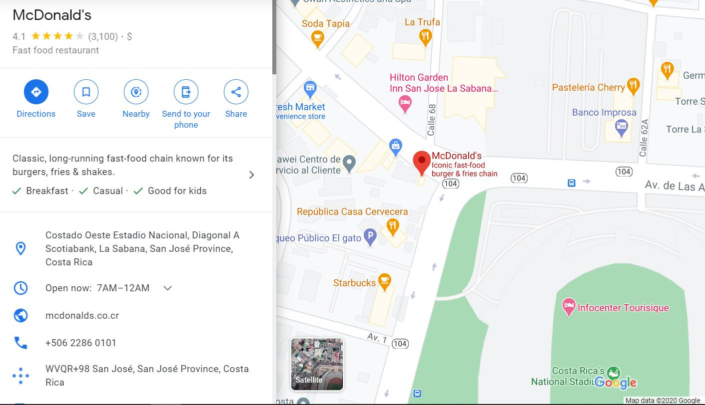
This McDonald's restaurant listing on Google Maps has a street address listing of (translated from Spanish) "On the west side of National Stadium, diagonally across the street from Scotiabank, in the La Sabana district, San José province, Costa Rica." Sending them a postcard from your vacation? Remember that address. That's how you'll get it there.
Now, look at the bottom of the listing. You'll see a plus-sign-shaped graphic made of blue dots, with the following description, "WVQR+98 San José, San José Province, Costa Rica". This is the Plus Code location for this McDonald's. The code states it's on grid WVQR+98, in the city of San Jose, San Jose province, Costa Rica.
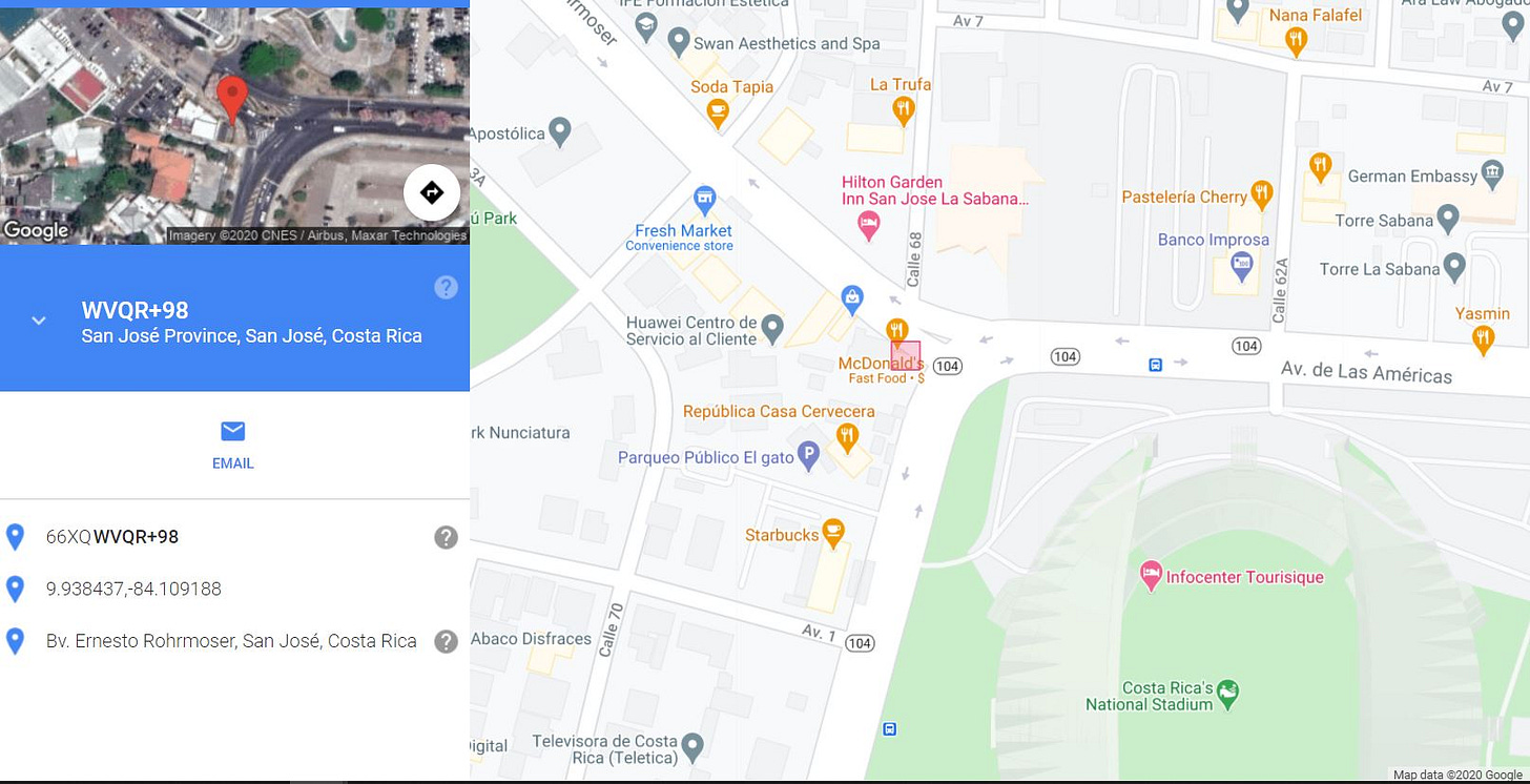
To illustrate the actual grid location and size, we can go to the website plus.codes and paste this code. It returns the following rendition of the same map, with the actual physical grid for that Plus Code shown in red. You'll see that the grid is indeed small.
If you look at the left-hand column, you'll see this tiny grid represented in 3 different ways:
WVQR+98 San José Province, San José, Costa Rica
The Plus Code66XQWVQR+98
An equivalent fully alphanumerical version of the Plus Code. The 66XQ equates to "San José Province, San José, Costa Rica." For remote locations not associated with a named place, this would be the code version on which to depend.9.938437,-84.109188
Latitude/Longitude
Pro Tip: This lat/long conversion is extremely useful if you want to program a Google Maps location that doesn't have a street address into a navigation tool that doesn't support Plus Codes!
Looking forward, it appears that the island nation of Cape Verde, portions of Kolkata (Calcutta) India, and the Navajo Nation are accepting Plus Codes as mailing addresses. And I haven't even touched on other essential uses… having a Plus Code as an address in an address-less locale also helps with registering as a voter, obtaining a bank account, directing emergency services, and medical/social services outreach. I'm sure there's more to come.
PS- I used the example of an address-less, yet quite visible fast food outlet on a capital city street corner. Now imagine densely populated unnamed streets and alleyways within global inner cities, and you compound the challenge even further- likewise for remote locations. The first few short videos are impressive in illustrating how Plus Codes are actively changing lives in places like these for the better.
The last video is for those interested in learning how to access Plus Code grids on Google Earth. Please enjoy!


